





July 6, 2026
Why GPS Was Never Designed for Indoor Environments

GPS has become one of the most invisible technologies in modern life. We open a map, follow the blue dot, and expect it to know exactly where we are. While the expectation holds outdoors, indoors is a different story.
The moment a user steps inside a hospital, airport, university building, office complex, shopping mall, or underground facility, GPS can quickly become unreliable. The blue dot may drift, jump to the wrong location, or fail to identify which floor the user is on. In some cases, it disappears altogether.
This is due to the inherent nature of GPS: it was built for open-sky positioning. Its architecture depends on satellites, precise timing, and relatively unobstructed signal paths between space and Earth. Different construction materials and structural elements can weaken or block satellite signals, ultimately failing to geolocate a device.
Understanding why requires a closer look at how GPS works, the unique challenges of indoor environments, and why alternative positioning technologies continue to gain attention across industries.
The History of GPS: A System Built for Open-Sky Navigation

GPS was originally developed by the U.S. Department of Defense as a military navigation system. The modern NAVSTAR GPS program began in the 1970s, with the first satellite launching in 1978. By the mid-1990s, the system had reached full operational capability.
Rather than building location infrastructure across roads and cities, GPS placed its infrastructure in space. Satellites broadcast signals that allow receivers on Earth to calculate their position. This approach transformed geospatial intelligence.
When GPS was designed in the 1970s and 1980s, indoor positioning was not considered a significant requirement. Smartphones did not exist, indoor wayfinding was not a consumer need, and tracking people or assets inside buildings was not a widespread use case.
The primary objective was to provide reliable, global positioning for military, aviation, maritime, and transportation applications. As a result, GPS was optimized for worldwide coverage and high accuracy in outdoor environments.
Today, most smartphones and navigation devices rely on multiple Global Navigation Satellite Systems (GNSS), including the U.S. GPS, Europe's Galileo, Russia's GLONASS, and China's BeiDou constellations. Together, these networks comprise more than 120 navigation satellites orbiting Earth, providing extensive global coverage and allowing outdoor devices to maintain highly reliable positioning.
How GPS Determines Your Location
The Global Positioning System (GPS) relies on a network of satellites orbiting Earth. Each satellite continuously broadcasts signals containing its location and precise time information.
A GPS receiver, such as a smartphone, calculates its position by measuring how long it takes signals from multiple satellites to reach the device. By comparing signals from at least four satellites, the receiver can determine its location on the Earth's surface.
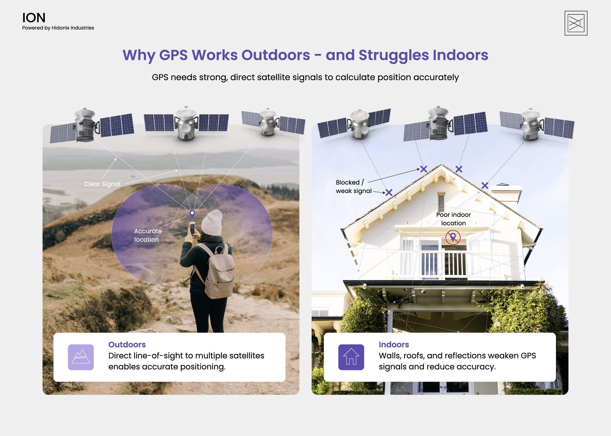
This approach works remarkably well in open outdoor environments where the receiver has a clear line of sight to the sky. Under ideal conditions, modern GPS systems can achieve location accuracy within a few meters. Enhanced satellite systems and correction technologies can improve that accuracy even further.
The key phrase, however, is clear line of sight.
Why GPS Signals Struggle Indoors
GPS signals are surprisingly weak by the time they reach Earth. A signal must travel more than 12,000 miles (20,000 kilometers) from a satellite to a receiver on the ground.
Outdoors, receivers can still detect those signals because the path is relatively open. Indoors, the signal must pass through a building first. This creates three major problems: attenuation, multipath, and faulty floor detection.
1. Attenuation: Buildings Weaken the Signal
Attenuation means a signal loses strength as it passes through physical materials.
GPS signals were not designed to penetrate buildings with high reliability. A signal may weaken as it passes through the roof, loss strength through interior walls, and become nearly unusable in basements, elevators, stairwells, or windowless rooms.
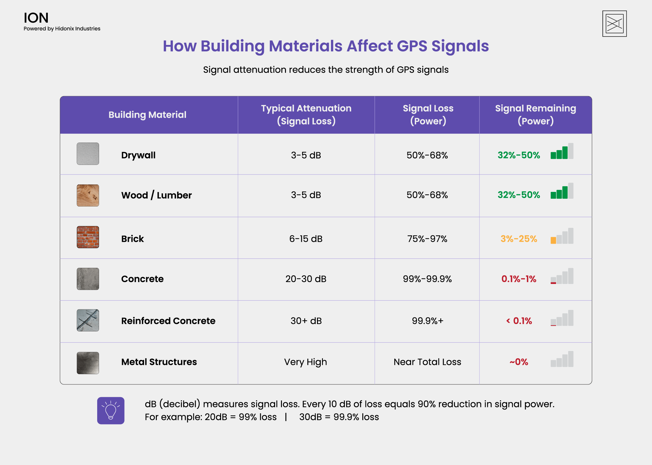
Source: "Electromagnetic Signal Attenuation in Construction Materials", NIST Interagency/Internal Report (NISTIR) - 6055
This is why GPS may work near a window, but fail deeper inside a facility. Large venues accentuate this challenge. Airports, hospitals, warehouses, and office towers often include thick construction materials, multiple floors, mechanical systems, and complex interior layouts. Each layer adds more interference.
2. Multipath: Signals Bounce Before They Arrive
GPS depends on timing. The receiver estimates distance by measuring how long a signal took to travel from satellite to device.
Multipath occurs when a signal bounces off surfaces before reaching the receiver. Indoors, signals can reflect off glass, steel, and other structures. Instead of receiving one clean signal, the device may receive several reflected versions of the same signal.
Those reflected signals travel longer paths, so they arrive slightly later. That timing error can make the receiver calculate the wrong distance from the satellite.
The result is the familiar indoor GPS experience: a blue dot that jumps, drifts, lags, or places the user in the wrong location.
3. Floor Detection: GPS Does Not Understand Building Levels
Vertical positioning is one of the hardest indoor challenges.
In a multi-story building, latitude and longitude are not enough. A user may be in the lobby, on the fifth floor, in the basement, or on a mezzanine, all within nearly the same horizontal footprint.
This matters in everyday navigation, but it becomes critical in emergencies. For example, the U.S. Federal Communications Commission (FCC) recognized that traditional location data is often not precise enough during emergencies inside buildings.
To address this, the FCC established a standard requiring compatible mobile devices to determine a caller's vertical location (or floor level) within approximately 3 meters for most indoor 911 calls. This benchmark reflects a simple truth: knowing the building alone is not enough. Emergency responders need accurate floor-level location data to reach people faster and save lives. If a system cannot understand floors, it cannot provide reliable indoor navigation.
To create a GPS-like experience indoors, a building needs its own positioning logic: reference points, signal measurements, sensor data, maps, floor awareness, and routing intelligence.
The Rise of Geomagnetic Positioning

The limitations of GPS indoors have driven the development of alternative positioning technologies such as traditional Wi-Fi, Bluetooth beacons, Ultra-Wideband (UWB), and RFID systems. These solutions often power Real-Time Location Systems (RTLS) for indoor navigation, asset tracking, and location intelligence. While effective in many environments, they typically require dedicated infrastructure, ongoing maintenance, or additional deployment costs.
Geomagnetic positioning takes a different approach. Every building naturally creates unique distortions in Earth's magnetic field due to its structural materials and layout. These distortions form a distinct magnetic fingerprint that can be mapped and used for positioning.
Rather than relying on beacons, tags, or expensive hardware, geomagnetic positioning leverages sensors already built into modern smartphones. A phone's magnetometer continuously measures subtle variations in the surrounding magnetic field, while proprietary positioning algorithms combine this data with motion sensors and digital maps to determine a user's location.
By using magnetic patterns that already exist within a building and the smartphone users already carry, platforms like Hidonix ION can deliver precise indoor-outdoor navigation and floor-aware wayfinding with no infrastructure requirements.
As demand for accurate indoor positioning continues to grow, geomagnetic technology is helping extend the familiar blue-dot navigation experience to places where GPS was never designed to work.